
Dramatic Weather Shift Brings Relief and Chaos to South Central Texas
In late May 2025, the residents of San Antonio and the broader South Central Texas region witnessed a dramatic weather shift that brought both relief and chaos. After enduring months of an exceptional drought, the area was suddenly hit by intense storms that dumped several inches of rain in a short span, leading to widespread flash flooding, traffic disruptions, power outages, and public safety concerns. The downpour began picking up around May 26, when strong thunderstorms swept across the Hill Country. These storms were powerful enough to produce hail the size of lemons, bright lightning flashes, and bursts of heavy rainfall. Areas such as Fredericksburg and other parts of Gillespie and Kendall counties were particularly hard-hit. While tornado watches were issued, none were confirmed, but the storm system was intense enough to rattle homes, damage property, and flood roads.
San Antonio Sees Most Significant Rainfall in Over a Year
In San Antonio, the impact was immediate. The city recorded over 2 inches of rain in just one day on May 26 — a volume not seen in over 16 months. This significant rainfall brought the total for the year to just over 8 inches, which, while a marked improvement, still left the region more than 4 inches below the usual annual average. The water levels in the Edwards Aquifer, a crucial source of water for the region, remained critically low despite receiving some rainfall over its recharge zones. San Antonio, having faced one of its most severe droughts in decades, has remained under Stage 5 drought restrictions, which is the highest level, reflecting the deep water shortages the city is still grappling with.
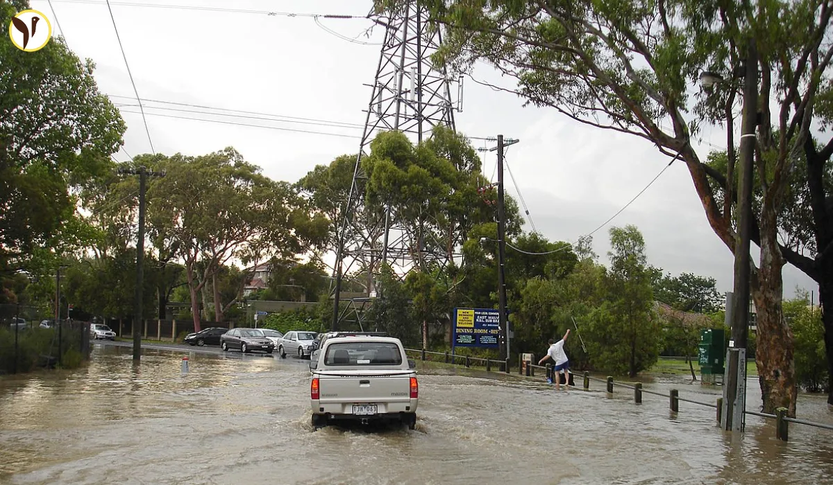
Infrastructure Struggles Amid Flooding Chaos
The rainfall, although welcome for water levels and agriculture, brought major challenges to infrastructure and mobility. Flooding forced the closure of several roads and low water crossings. San Antonio, known for its 144 low-water crossings, had to deploy multiple Public Works flood response teams across the city. These teams worked around the clock to erect barricades and monitor flooding in real-time. Residents were repeatedly warned not to drive through flooded streets, as even one foot of water is enough to sweep away a small vehicle, and standing water as shallow as a few inches can become life-threatening.
Power Outages Add to Residents' Woes
Power infrastructure took a beating as well. At the height of the storm, more than 1,500 CPS Energy customers were left without electricity. The hardest-hit areas included the Northwest, West, and Far West sides of the city. Fallen tree limbs and water-damaged lines were the major culprits, despite CPS Energy’s recent investments in aggressive tree trimming and infrastructure resilience. Crews worked quickly to restore power, but the event highlighted the need for continued upgrades to cope with increasingly erratic weather patterns.
Continued Flood Risks Keep Region on Alert
Even as the city began to dry out, the risk wasn’t completely over. The National Weather Service issued flash flood warnings that extended into the morning of May 28. Residents were cautioned to remain vigilant, especially during nighttime hours when flooded areas are harder to detect. Several counties, including Bexar, Kendall, and Comal, remained on high alert due to the ongoing risk of rising water in creeks, streams, and low-lying urban areas. Emergency officials reiterated the importance of avoiding unnecessary travel and obeying road closure signs to prevent accidents and water rescues.
Extreme Weather Highlights Growing Climate Challenges
While the storms brought temporary relief to the dry landscape, they also served as a stark reminder of the volatility of Texas weather. The sudden swing from drought to deluge is becoming increasingly common, posing complex challenges for city planners, emergency services, and residents alike. San Antonio’s experience this week showed the importance of being prepared for both extremes — with adequate drainage systems, emergency protocols, and public awareness campaigns. Though the clouds may be parting and temperatures expected to drop slightly with an approaching cold front, the memory of these storms will likely linger in the minds of those who lived through them, as a clear signal that climate unpredictability is now part of daily life.