
In the last days of May 2025, powerful tornadoes and storms hit several parts of the United States. From the southern states like Georgia and Kentucky to the Mid-Atlantic and Northeast, millions of people faced intense weather, including high winds, heavy rain, and flooding. Tornado watches and warnings were issued in different regions as weather conditions shifted quickly. Many homes were damaged or destroyed, roads flooded, and power outages were reported in some towns. People were urged to stay inside, monitor weather alerts, and prepare for more storms. This round of severe weather shows how unpredictable spring and early summer storms can be in many parts of the country.
Tornado Strikes Kentucky, Leaves One Dead
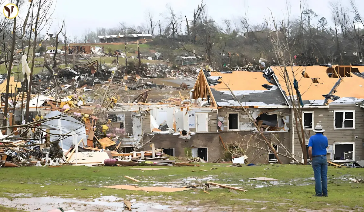
On May 30, a dangerous tornado hit Washington County, Kentucky, early in the day. The storm brought strong winds that tore through homes and buildings, leaving a trail of destruction behind. One person lost their life due to the storm, and several others were injured. Local officials and rescue teams quickly responded, helping those who were hurt and clearing blocked roads. Photos from the area showed homes completely destroyed and trees ripped from the ground. Power lines were also down, cutting off electricity in parts of the county. The community is now working together to clean up and help those who lost their homes. Tornadoes like this remind everyone how quickly life can change when extreme weather hits.
Georgia Tornado Destroys Homes, Injures Teen
Another strong tornado hit Locust Grove, Georgia, causing serious damage. Among those affected was actor Tray Chaney, known for his role in The Wire. His home was completely destroyed by the tornado. His 18-year-old son, Malachi, was critically hurt after the storm threw him hundreds of feet away from their house. The tornado was confirmed to be an EF2, which means it had wind speeds as high as 135 miles per hour. Several other homes in the area were also damaged, and local officials are helping residents recover. This tragic event shows just how dangerous and sudden tornadoes can be, especially in residential areas. Emergency crews continue to search for damage and provide support to those affected by the storm.
Tornado Watches Issued in the Mid-Atlantic
The National Weather Service issued tornado watches across several Mid-Atlantic states, including Delaware, Maryland, Virginia, New Jersey, and Pennsylvania. These alerts were meant to prepare people in case a tornado formed nearby. A watch means that the weather conditions could lead to a tornado, so people should be ready to take cover. In some areas, like New Castle County in Delaware, the alerts turned into warnings, which means a tornado was seen or detected on radar. Schools and businesses in those areas took precautions, and many residents received emergency alerts on their phones. While most warnings ended within a few hours, the weather remained unsettled with heavy rain and strong wind. The quick changes in conditions show how important it is to take watches and warnings seriously.
Flash Flooding and Rain Continue
Even after the tornado risk faded, strong rainstorms continued to cause problems, especially in Philadelphia, South Jersey, and parts of New York. Flood warnings were issued due to the heavy rainfall, and some roads became too dangerous to drive on. Flash floods can happen quickly, especially when the ground is already soaked. People were advised not to drive through water-covered streets, as just a few inches of water can sweep away cars. Local officials also warned residents living near rivers and streams to be on alert for rising water levels. Weather experts said the rain could continue into the next morning, so it’s important to stay informed and take precautions. Flash flooding often causes more damage than people expect, especially in urban areas where drainage is limited.
Which Areas Are Still at Risk?
Although the worst of the storms have passed, some areas are still dealing with the effects. Places that saw the most rain, like parts of New Jersey, Pennsylvania, and Delaware, are facing flood risks. River levels are high, and any additional rain could cause more flooding. Emergency management teams are watching these areas closely. Meanwhile, utility crews are working to restore power to neighborhoods affected by strong winds and fallen trees. If you live in a region that experienced heavy weather, it’s important to stay aware of local forecasts. Weather patterns can shift fast, and new storms could form. Keep an emergency kit ready and know your local shelter options just in case conditions worsen again.
How to Stay Safe During Severe Weather
Severe weather can happen with little warning, so it’s important to be prepared. Start by signing up for local weather alerts through the National Weather Service or weather apps. These alerts can give you time to find shelter. Keep an emergency kit at home with essentials like water, non-perishable food, flashlights, and first-aid supplies. Know the safest part of your home to go during a tornado—usually a basement or an interior room without windows. Avoid being outside during storms, and never try to drive through floodwaters. If you live in a mobile home, have a plan to move to a safer location if a tornado watch is issued. Being ready can make a big difference in how well you and your family get through dangerous weather events.
Image Source: Ruters